-
Smart Construction Phantom 4 RTK
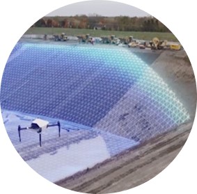
A bird’s-eye view to accurately map your jobsite, in a fraction of the time required by a ground-based survey.
Features
- High precision point clouds
- Plan your work with accuracy
- Useful information for improved reporting
Resources
- Login to Purchase
A high-precision mapping drone can be 50% faster than a walking survey, and its boots never get muddy. Bid packages come with an existing topo, but is it up to date? Even if it is, it will likely lack the level of detail you need. Drone mapping helps with planning, but also sends data as you progress, giving you information that you can turn into efficiencies and better reporting. Whether you buy one yourself or have us do it, ask a Komatsu expert to show you why you should fly. Comes with (1) Aeropoint ground control point unit, (2) batteries, (1) charging hub, and a 1-year manufacturer's warranty.
.jpg)
.jpg)
.jpg)
Add to Shopping Cart
Smart Construction Phantom 4 RTK
Select subscription Type